Geolocate

Dresden topographic map

Click on the map to display elevation.

About this map

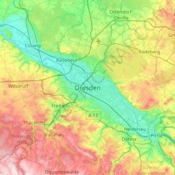
Name: Dresden topographic map, elevation, terrain.

Location: Dresden, Saxony, 01069, Germany (50.88933 13.57814 51.20933 13.89814)

Average elevation: 778 ft

Minimum elevation: 318 ft

Maximum elevation: 1,634 ft

Other topographic maps

Click on a map to view its topography, its elevation and its terrain.

01237

Germany > Saxony > Dresden

Average elevation: 397 ft

Innere Altstadt

Germany > Saxony > Dresden

Dresden lies on both banks of the Elbe, mostly in the Dresden Basin, with the further reaches of the eastern Ore Mountains to the south, the steep slope of the Lusatian granitic crust to the north, and the Elbe Sandstone Mountains to the east at an altitude of about 113 metres (371 feet). Triebenberg is the…

Average elevation: 384 ft

Pirnaische Vorstadt

Germany > Saxony > Dresden

Average elevation: 381 ft

Friedrichstadt

Germany > Saxony > Dresden

Average elevation: 374 ft

Langebrück

Germany > Saxony > Dresden

Average elevation: 715 ft

Gear up for your next adventure:

🗃️Trail First Aid Kit - Essential kit for outdoor injuries and emergencies
🧭Orienteering Set - Complete compass and map reading kit
🧥Waterproof Jacket for Hiking - Breathable and rugged rain jacket for outdoor excursions
📷Action Camera - Capture your outdoor adventures in HD
🧼Biodegradable Camping Soap - Eco‑friendly soap for outdoor hygiene

As an Amazon Associate, this site earns from qualifying purchases at no extra cost to you.