
Thank you for supporting this site ❤️
Make a donation
Make a donation
Gear up for your next adventure:
As an Amazon Associate, this site earns from qualifying purchases at no extra cost to you.
Achocalla topographic map
Click on the map to display elevation.
Thank you for supporting this site ❤️
Make a donation
Make a donation
Gear up for your next adventure:
As an Amazon Associate, this site earns from qualifying purchases at no extra cost to you.
About this map
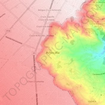
Name: Achocalla topographic map, elevation, terrain.
Location: Achocalla, Provincia Murillo, La Paz, 00020, Bolivia (-16.60810 -68.21101 -16.52810 -68.13101)
Average elevation: 12,700 ft
Minimum elevation: 11,214 ft
Maximum elevation: 13,343 ft
Thank you for supporting this site ❤️
Make a donation
Make a donation
Gear up for your next adventure:
As an Amazon Associate, this site earns from qualifying purchases at no extra cost to you.