
Make a donation
Gear up for your next adventure:
As an Amazon Associate, this site earns from qualifying purchases at no extra cost to you.
Bensberg topographic map
Click on the map to display elevation.
Make a donation
Gear up for your next adventure:
As an Amazon Associate, this site earns from qualifying purchases at no extra cost to you.
Bensberg
Mit der Kölner Stadtbahnlinie 1 (Bensberg – Köln-Weiden) erreicht man die Kölner Innenstadt in ungefähr einer halben Stunde. Die Linie endete früher in Höhe der Falltorstraße. Im Mai 2000 wurde der Tunnel für die Verlängerung der Strecke um 487 Meter bis zum Bus- und U-Bahnhof Bensberg in Betrieb genommen. Für eine Verlängerung der Linie über den Technologiepark nach Herkenrath und Spitze wurde 2017 eine Machbarkeitsstudie in Auftrag gegeben.
Make a donation
Gear up for your next adventure:
As an Amazon Associate, this site earns from qualifying purchases at no extra cost to you.
About this map
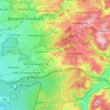
Name: Bensberg topographic map, elevation, terrain.
Average elevation: 456 ft
Minimum elevation: 174 ft
Maximum elevation: 876 ft
Make a donation
Gear up for your next adventure:
As an Amazon Associate, this site earns from qualifying purchases at no extra cost to you.
Other topographic maps
Click on a map to view its topography, its elevation and its terrain.
Kradepohlsmühle
Deutschland > Nordrhein-Westfalen > Rheinisch-Bergischer Kreis > Bergisch Gladbach > Kradepohlsmühle
Average elevation: 262 ft
51427
Deutschland > Nordrhein-Westfalen > Rheinisch-Bergischer Kreis > Bergisch Gladbach
Average elevation: 410 ft