Geolocate

West Allis topographic map

Click on the map to display elevation.

About this map

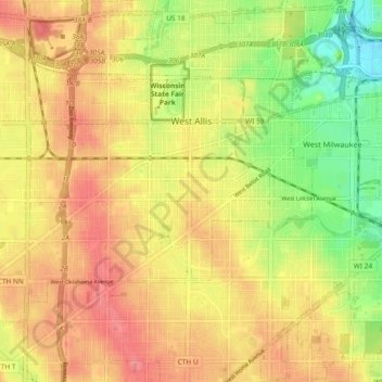
Name: West Allis topographic map, elevation, terrain.

Location: West Allis, Milwaukee County, Wisconsin, United States (42.97729 -88.06862 43.03101 -87.97551)

Average elevation: 735 ft

Minimum elevation: 597 ft

Maximum elevation: 833 ft

Milwaukee County trails, hiking, mountain biking, running and outdoor activities

Other topographic maps

Click on a map to view its topography, its elevation and its terrain.

Gear up for your next adventure:

😴Insulated Sleeping Pads - Compact and warm pads for high-elevation camping
🔭Stargazing Telescopes - Perfect for camping in low-light pollution areas shown on maps
🧦Merino Wool Socks - Moisture-wicking, blister-preventing socks for long treks
📱Solar Portable Charger - Solar power bank for charging devices off‑grid
🧺Microfiber Travel Towels - Compact and fast-drying towels for trail use

As an Amazon Associate, this site earns from qualifying purchases at no extra cost to you.