
Make a donation
Gear up for your next adventure:
As an Amazon Associate, this site earns from qualifying purchases at no extra cost to you.
El Cerinal topographic map
Click on the map to display elevation.
Make a donation
Gear up for your next adventure:
As an Amazon Associate, this site earns from qualifying purchases at no extra cost to you.
About this map
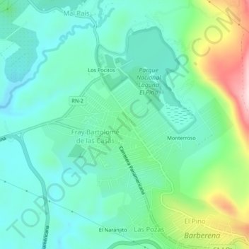
Name: El Cerinal topographic map, elevation, terrain.
Location: El Cerinal, Barberena, Santa Rosa, Guatemala (14.31255 -90.41848 14.35255 -90.37848)
Average elevation: 3,494 ft
Minimum elevation: 3,205 ft
Maximum elevation: 4,337 ft
Make a donation
Gear up for your next adventure:
As an Amazon Associate, this site earns from qualifying purchases at no extra cost to you.
Other topographic maps
Click on a map to view its topography, its elevation and its terrain.
Laguna El Pino
Guatemala > Santa Rosa > Barberena > El Cerinal > Los Pocitos
Average elevation: 3,540 ft
Laguna El Pino
Guatemala > Santa Rosa > Barberena > El Cerinal > Los Pocitos
Average elevation: 3,540 ft