Geolocate

Stanthorpe topographic map

Click on the map to display elevation.

Stanthorpe

Owing to its elevation, Stanthorpe features a subtropical highland climate. At an altitude of 811 metres (2,661 ft), Stanthorpe holds the record for the lowest temperature recorded in Queensland at −10.6 °C (12.9 °F) on 23 June 1961. Sleet and light snowfalls are occasionally recorded, with the most significant snowfall in over 30 years occurring on 17 July 2015.

About this map

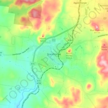
Name: Stanthorpe topographic map, elevation, terrain.

Location: Stanthorpe, Southern Downs Regional, Queensland, 4380, Australia (-28.69599 151.89383 -28.61599 151.97383)

Average elevation: 2,756 ft

Minimum elevation: 2,493 ft

Maximum elevation: 3,169 ft

Gear up for your next adventure:

🗃️Trail First Aid Kit - Essential kit for outdoor injuries and emergencies
🔭Stargazing Telescopes - Perfect for camping in low-light pollution areas shown on maps
🚑Emergency Bivvies - Heat-reflective sleeping bags for survival situations
🔥Plasma Lighters - Windproof lighters that work in any weather condition
🪓Survival Multi‑Tool - Versatile tool for camp and trail tasks

As an Amazon Associate, this site earns from qualifying purchases at no extra cost to you.