
Thank you for supporting this site ❤️
Make a donation
Make a donation
Gear up for your next adventure:
As an Amazon Associate, this site earns from qualifying purchases at no extra cost to you.
Sorata topographic map
Click on the map to display elevation.
Thank you for supporting this site ❤️
Make a donation
Make a donation
Gear up for your next adventure:
As an Amazon Associate, this site earns from qualifying purchases at no extra cost to you.
About this map
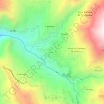
Name: Sorata topographic map, elevation, terrain.
Location: Sorata, Provincia Larecaja, LPZ, Bolivia (-15.79281 -68.66993 -15.75281 -68.62993)
Average elevation: 9,393 ft
Minimum elevation: 7,657 ft
Maximum elevation: 11,775 ft
Thank you for supporting this site ❤️
Make a donation
Make a donation
Gear up for your next adventure:
As an Amazon Associate, this site earns from qualifying purchases at no extra cost to you.