
West Coast Division topographic map
Interactive map
Click on the map to display elevation.
About this map
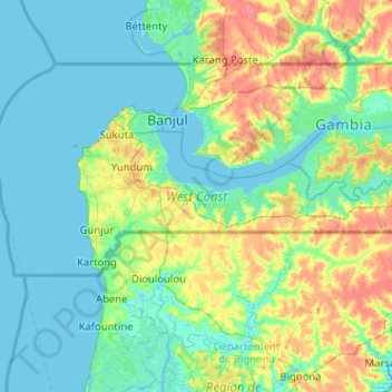
Name: West Coast Division topographic map, elevation, terrain.
Location: West Coast Division, The Gambia (13.06395 -16.82378 13.45308 -15.80361)
Average elevation: 36 ft
Minimum elevation: -10 ft
Maximum elevation: 167 ft
The Gambia is the smallest country in Africa and the width of the strip-like structure never exceeds 48 km (30 mi). It is bordered by the Atlantic Ocean to the west, and otherwise surrounded by Senegal. The Gambia River flows throughout the country and is the principal source of water and a transport route. The banks of the river have swampy beaches, while it has alluvial soil in all other parts, which is conducive for the growth of rice. Peanuts are the major cash crop. The weather is usually warm and dry.[1] The elevation of the country reaches to a maximum of 50 m (160 ft) above the mean sea level. There are vast segments of sedimentary sandstone and claystone in the valleys of the rivers and the regions surrounding it. The river flows from Guinea and has an east–west axis. The shallow water in the coastline are important sources of fishing. They are mangrove and banto forests along the coastline.[2] Over the river segment of 487 km (303 mi), there are numerous creeks, which are locally called boloons. The months from June to September experience a wet season, while the remaining seven months are dry. The average annual rainfall is around 1,400 mm (55 in) in the south east, while it is 720 mm (28 in) in the northwest. Experts have assessed that the overall rainfall during the century period between 1886 and 1992, there has been a reduction in rainfall of around 15-20 per cent and the wet season has been shortened.[3]
Other topographic maps
Click on a map to view its topography, its elevation and its terrain.
Banjul
The Gambia > Kombo North/Saint Mary
Banjul, Kombo North/Saint Mary, The Gambia
Average elevation: 3 ft
Basse
The Gambia > Upper River Division
Basse, Upper River Division, The Gambia
Average elevation: 131 ft
Tumana
The Gambia > Upper River Division
Tumana, Basse, Upper River Division, The Gambia
Average elevation: 102 ft
Kartong
The Gambia > West Coast Division > Kartong
Kartong, Brikama, West Coast Division, The Gambia
Average elevation: 10 ft
Banjul
The Gambia > Banjul City Council > Banjul
Banjul, Banjul City Council, The Gambia
Average elevation: 3 ft
Seawall
The Gambia > West Coast Division > Seawall
Seawall, Brikama, West Coast Division, The Gambia
Average elevation: 102 ft
Kunta Kinteh Island
The Gambia > North Bank Division > Upper Niumi
Kunta Kinteh Island, Upper Niumi, Kerewan, North Bank Division, The Gambia
Average elevation: -3 ft
Banjul
The Gambia > Banjul City Council
Banjul, Banjul City Council, The Gambia
Average elevation: 0 ft
Mariama Kunda
The Gambia > West Coast Division (The Gambia) > Kombo North/Saint Mary > Mariama Kunda
Mariama Kunda, Kombo North/Saint Mary, Brikama, West Coast Division (The Gambia), The Gambia
Average elevation: 52 ft
Gunjur
The Gambia > West Coast Division
Gunjur, Brikama, West Coast Division, The Gambia
Average elevation: 33 ft