Geolocate

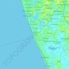
Sarikkamulla topographic map

Click on the map to display elevation.

About this map

Name: Sarikkamulla topographic map, elevation, terrain.

Location: Sarikkamulla, Panadura DS Division, Kalutara District, Western Province, 12550, Sri Lanka (6.73272 79.87981 6.77272 79.91981)

Average elevation: 20 ft

Minimum elevation: -7 ft

Maximum elevation: 92 ft

Other topographic maps

Click on a map to view its topography, its elevation and its terrain.
Gear up for your next adventure:

🔭Stargazing Telescopes - Perfect for camping in low-light pollution areas shown on maps
🪶Compact Camp Shovel - Folding shovel for campsite tasks
🎒Gear Packing Cubes - Organize your backpack efficiently
🦶Carbon Trekking Poles - Reduce knee impact on steep descents with ultra-light poles
⛺Backpacking Tents - Weight-optimized shelters for multi-day topographic surveys

As an Amazon Associate, this site earns from qualifying purchases at no extra cost to you.