
Make a donation
Gear up for your next adventure:
As an Amazon Associate, this site earns from qualifying purchases at no extra cost to you.
Carrazeda de Ansiães topographic map
Click on the map to display elevation.
Make a donation
Gear up for your next adventure:
As an Amazon Associate, this site earns from qualifying purchases at no extra cost to you.
About this map
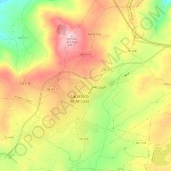
Name: Carrazeda de Ansiães topographic map, elevation, terrain.
Location: Carrazeda de Ansiães, Distrito de Bragança, Portugal (41.22525 -7.32032 41.26843 -7.27960)
Average elevation: 2,454 ft
Minimum elevation: 1,893 ft
Maximum elevation: 2,917 ft
Make a donation
Gear up for your next adventure:
As an Amazon Associate, this site earns from qualifying purchases at no extra cost to you.
Other topographic maps
Click on a map to view its topography, its elevation and its terrain.
Codeçais
Portugal > Distrito de Bragança > Carrazeda de Ansiães > Pereiros
Average elevation: 1,188 ft
Pinhal do Douro
Portugal > Distrito de Bragança > Carrazeda de Ansiães > Vilarinho da Castanheira
Average elevation: 1,677 ft
Make a donation
Gear up for your next adventure:
As an Amazon Associate, this site earns from qualifying purchases at no extra cost to you.
Miradouro de São Lourenço
Portugal > Distrito de Bragança > Carrazeda de Ansiães > Pombal > São Lourenço
Average elevation: 1,184 ft
Make a donation
Gear up for your next adventure:
As an Amazon Associate, this site earns from qualifying purchases at no extra cost to you.