
Make a donation
Gear up for your next adventure:
As an Amazon Associate, this site earns from qualifying purchases at no extra cost to you.
Mâcot-la-Plagne topographic map
Click on the map to display elevation.
Make a donation
Gear up for your next adventure:
As an Amazon Associate, this site earns from qualifying purchases at no extra cost to you.
Mâcot-la-Plagne
La commune de Mâcot-la-Plagne se situe au cœur de la Tarentaise sur le versant de l'ubac et s'étage de 600 à 2 700 mètres d'altitude.
Make a donation
Gear up for your next adventure:
As an Amazon Associate, this site earns from qualifying purchases at no extra cost to you.
About this map
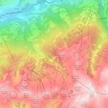
Name: Mâcot-la-Plagne topographic map, elevation, terrain.
Average elevation: 5,840 ft
Minimum elevation: 2,070 ft
Maximum elevation: 8,934 ft
Make a donation
Gear up for your next adventure:
As an Amazon Associate, this site earns from qualifying purchases at no extra cost to you.
Other topographic maps
Click on a map to view its topography, its elevation and its terrain.
Make a donation
Gear up for your next adventure:
As an Amazon Associate, this site earns from qualifying purchases at no extra cost to you.
Plan Gagnant
France > Auvergne-Rhône-Alpes > Savoie > La Plagne-Tarentaise
Average elevation: 5,213 ft
Make a donation
Gear up for your next adventure:
As an Amazon Associate, this site earns from qualifying purchases at no extra cost to you.
Mâcot-la-Plagne
France > Auvergne-Rhône-Alpes > Savoie > La Plagne-Tarentaise
Average elevation: 3,330 ft
Make a donation
Gear up for your next adventure:
As an Amazon Associate, this site earns from qualifying purchases at no extra cost to you.
Le Ceriseray
France > Auvergne-Rhône-Alpes > Savoie > La Plagne-Tarentaise
Average elevation: 4,596 ft
Belle Plagne
France > Auvergne-Rhône-Alpes > Savoie > La Plagne-Tarentaise
Average elevation: 7,231 ft
Make a donation
Gear up for your next adventure:
As an Amazon Associate, this site earns from qualifying purchases at no extra cost to you.
Plan d'eau Base de loisirs
France > Auvergne-Rhône-Alpes > Savoie > La Plagne-Tarentaise > Le Villard de Sangot
Average elevation: 3,074 ft
Plagne Villages
France > Auvergne-Rhône-Alpes > Savoie > La Plagne-Tarentaise
Average elevation: 6,903 ft
Make a donation
Gear up for your next adventure:
As an Amazon Associate, this site earns from qualifying purchases at no extra cost to you.
Plagne Centre
France > Auvergne-Rhône-Alpes > Savoie > La Plagne-Tarentaise
Average elevation: 6,818 ft
Les Chacruets
France > Auvergne-Rhône-Alpes > Savoie > La Plagne-Tarentaise
Average elevation: 3,638 ft
Plagne Soleil
France > Auvergne-Rhône-Alpes > Savoie > La Plagne-Tarentaise
Average elevation: 6,870 ft
Make a donation
Gear up for your next adventure:
As an Amazon Associate, this site earns from qualifying purchases at no extra cost to you.
Le Villard de Sangot
France > Auvergne-Rhône-Alpes > Savoie > La Plagne-Tarentaise
Average elevation: 3,556 ft
Plagne Centre
France > Auvergne-Rhône-Alpes > Savoie > La Plagne-Tarentaise
Average elevation: 6,818 ft