
Make a donation
Gear up for your next adventure:
As an Amazon Associate, this site earns from qualifying purchases at no extra cost to you.
Münklingen topographic map
Click on the map to display elevation.
Make a donation
Gear up for your next adventure:
As an Amazon Associate, this site earns from qualifying purchases at no extra cost to you.
About this map
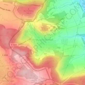
Name: Münklingen topographic map, elevation, terrain.
Average elevation: 1,614 ft
Minimum elevation: 1,230 ft
Maximum elevation: 1,896 ft
Make a donation
Gear up for your next adventure:
As an Amazon Associate, this site earns from qualifying purchases at no extra cost to you.
Other topographic maps
Click on a map to view its topography, its elevation and its terrain.
Wasenhof
Deutschland > Baden-Württemberg > Landkreis Böblingen > Weil der Stadt
Average elevation: 1,457 ft
Merklingen
Deutschland > Baden-Württemberg > Landkreis Böblingen > Weil der Stadt
Average elevation: 1,430 ft
Kuppelzen
Deutschland > Baden-Württemberg > Landkreis Böblingen > Weil der Stadt
Average elevation: 1,552 ft
Schafhausen
Deutschland > Baden-Württemberg > Landkreis Böblingen > Weil der Stadt > Schafhausen
Average elevation: 1,506 ft
Make a donation
Gear up for your next adventure:
As an Amazon Associate, this site earns from qualifying purchases at no extra cost to you.