
Dagana District topographic map
Interactive map
Click on the map to display elevation.
About this map
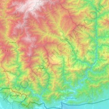
Name: Dagana District topographic map, elevation, terrain.
Location: Dagana District, Bhutan (26.70169 89.63332 27.27182 90.06528)
Average elevation: 5,525 ft
Minimum elevation: 299 ft
Maximum elevation: 15,407 ft
Other topographic maps
Click on a map to view its topography, its elevation and its terrain.
Tashigang
Bhutan > Dagana District > Tseza Gewog
Tashigang, Tseza Gewog, Dagana District, Bhutan
Average elevation: 7,694 ft
Daga
Bhutan > Dagana District > Tseza Gewog > Karlingzingkha
Daga, Karlingzingkha, Tseza Gewog, Dagana District, Bhutan
Average elevation: 5,846 ft