Geolocate

Fontignani topographic map

Click on the map to display elevation.

About this map

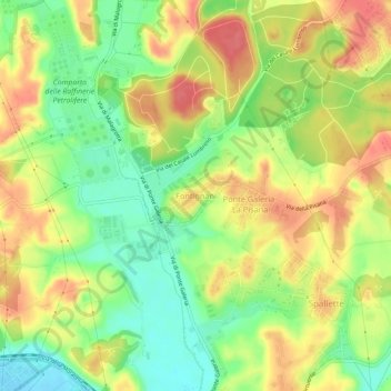
Name: Fontignani topographic map, elevation, terrain.

Location: Fontignani, Rome, Roma Capitale, Lazio, Italy (41.82557 12.32011 41.86557 12.36011)

Average elevation: 118 ft

Minimum elevation: -7 ft

Maximum elevation: 230 ft

Other topographic maps

Click on a map to view its topography, its elevation and its terrain.

Parco del Colle Oppio

Italy > Lazio > Roma Capitale > Rome

Average elevation: 157 ft

Giardini del Quirinale

Italy > Lazio > Roma Capitale > Rome

Average elevation: 161 ft

Parco della Caffarella

Italy > Lazio > Roma Capitale > Rome

Average elevation: 141 ft

Parco Eros Corizza

Italy > Lazio > Roma Capitale > Rome

Average elevation: 118 ft

Gear up for your next adventure:

🦺Reflective Outdoor Gear - Safety gear for low‑light conditions
🧭Map Reading Tools - Tools and kits for map navigation
😴Insulated Sleeping Pads - Compact and warm pads for high-elevation camping
🌡️Portable Weather Meter - Track weather conditions on the trail
🪶Wildlife Field Guides - Learn animal tracking and species ID

As an Amazon Associate, this site earns from qualifying purchases at no extra cost to you.