Geolocate

Elthuruth topographic map

Click on the map to display elevation.

About this map

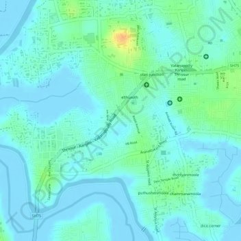
Name: Elthuruth topographic map, elevation, terrain.

Location: Elthuruth, Thrissur, Thrissur District, Kerala, India (10.50603 76.16209 10.51875 76.18890)

Average elevation: 26 ft

Minimum elevation: -20 ft

Maximum elevation: 115 ft

Other topographic maps

Click on a map to view its topography, its elevation and its terrain.

Poomala Dam

India > Kerala > Thrissur > Thrissur

Average elevation: 325 ft

Poomala Dam

India > Kerala > Thrissur > Thrissur

Average elevation: 325 ft

Gear up for your next adventure:

🚪Portable Camp Chair - Foldable chair for comfort at camp
👟Trail Running Shoes - Lightweight shoes for trail runners
🧴Hand Sanitizer - Keep hands clean while hiking
🎒Trekking Poles - Sturdy poles for balance and stability on rough terrain
🌡️Portable Weather Meter - Track weather conditions on the trail

As an Amazon Associate, this site earns from qualifying purchases at no extra cost to you.