
Make a donation
Gear up for your next adventure:
As an Amazon Associate, this site earns from qualifying purchases at no extra cost to you.
Kathmandu topographic map
Click on the map to display elevation.
Make a donation
Gear up for your next adventure:
As an Amazon Associate, this site earns from qualifying purchases at no extra cost to you.
Kathmandu
Kathmandu is located at an elevation of approximately 4,600 feet (1,400 meters) within the Kathmandu Valley. This valley is characterized by a bowl-like topography, encircled by the lower Himalayan ranges, which rise sharply in the north, culminating in peaks that exceed 24,000 feet (7,300 meters). The valley itself varies in elevation, with the terrain gently sloping from the surrounding hills down into the city center. The Kathmandu Valley's fertile land supports lush vegetation and agriculture, while the varied topography includes hills, valleys, and river systems, such as the Bagmati River, which flows through the region. This diverse landscape contributes to the region's rich biodiversity and distinct climatic variations, ranging from subtropical in the lower areas to alpine conditions in the higher elevations.
Make a donation
Gear up for your next adventure:
As an Amazon Associate, this site earns from qualifying purchases at no extra cost to you.
About this map
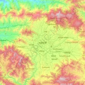
Name: Kathmandu topographic map, elevation, terrain.
Average elevation: 5,046 ft
Minimum elevation: 1,988 ft
Maximum elevation: 8,967 ft
Make a donation
Gear up for your next adventure:
As an Amazon Associate, this site earns from qualifying purchases at no extra cost to you.
Other topographic maps
Click on a map to view its topography, its elevation and its terrain.