Geolocate

Colville topographic map

Click on the map to display elevation.

About this map

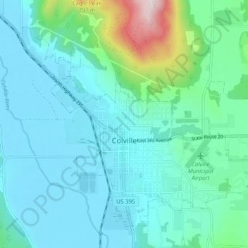
Name: Colville topographic map, elevation, terrain.

Location: Colville, Stevens County, Washington, United States (48.52959 -117.93649 48.56989 -117.86282)

Average elevation: 1,834 ft

Minimum elevation: 1,535 ft

Maximum elevation: 3,353 ft

Stevens County trails, hiking, mountain biking, running and outdoor activities

Other topographic maps

Click on a map to view its topography, its elevation and its terrain.

Gifford

United States > Washington > Stevens County

Average elevation: 1,650 ft

Grays

United States > Washington > Stevens County

Average elevation: 1,962 ft

Bissel

United States > Washington > Stevens County

Average elevation: 2,110 ft

Enterprise

United States > Washington > Stevens County

Average elevation: 1,962 ft

Tumtum

United States > Washington > Stevens County

Average elevation: 1,821 ft

Turk

United States > Washington > Stevens County

Average elevation: 3,114 ft

Rice

United States > Washington > Stevens County

Average elevation: 1,759 ft

Velvet

United States > Washington > Stevens County

Average elevation: 2,671 ft

Rocky Butte

United States > Washington > Stevens County

Average elevation: 3,346 ft

Ford

United States > Washington > Stevens County

Ford is located in a mountainous area at the base of Happy Hill, which rises more than 600 feet immediately to the southeast of the community. The northeast–southwest trending Walkers Prairie and valley floor along which Chamokane Creek flows is relatively flat and at an elevation of between 1,700 and 1,800…

Average elevation: 1,893 ft

Suncrest

United States > Washington > Stevens County

Average elevation: 1,854 ft

Wellpinit

United States > Washington > Stevens County

Average elevation: 2,500 ft

Mount Rogers

United States > Washington > Stevens County

Average elevation: 4,715 ft

Calispell Peak

United States > Washington > Stevens County

Average elevation: 5,801 ft

Colville

United States > Washington > Stevens County > Colville > Colville

Average elevation: 1,975 ft

Gear up for your next adventure:

🗃️Trail First Aid Kit - Essential kit for outdoor injuries and emergencies
📡GPS Antenna Upgrade - Enhance GPS reception in remote terrain
🥾Hiking Shoes - Durable and comfortable shoes for trail hiking
Backpacking Tents - Weight-optimized shelters for multi-day topographic surveys
🚁Photography Drones - Capture stunning aerial views of landforms and topography

As an Amazon Associate, this site earns from qualifying purchases at no extra cost to you.