Geolocate

Surulere topographic map

Click on the map to display elevation.

About this map

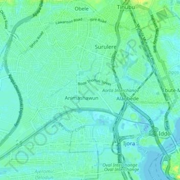
Name: Surulere topographic map, elevation, terrain.

Location: Surulere, Lagos State, 101212, Nigeria (6.45990 3.31563 6.51272 3.38298)

Average elevation: 20 ft

Minimum elevation: -13 ft

Maximum elevation: 72 ft

Other topographic maps

Click on a map to view its topography, its elevation and its terrain.

Falomo

Nigeria > Lagos State > Eti Osa

Average elevation: 16 ft

Victoria Island

Nigeria > Lagos State > Eti Osa

Average elevation: 33 ft

Tincan Island

Nigeria > Lagos State > Apapa

Average elevation: 10 ft

Ajah

Nigeria > Lagos State > Eti Osa

Average elevation: 10 ft

Epe

Nigeria > Lagos State > Badagry > Epe

Average elevation: 10 ft

Igbo

Nigeria > Lagos State > Eti Osa

Average elevation: 16 ft

Gear up for your next adventure:

🥩Freeze-Dried Meals - Nutritious and lightweight food for remote expeditions
🔪Outdoor Multitools - Essential survival tools for gear repair and field use
📡GPS Antenna Upgrade - Enhance GPS reception in remote terrain
👟Trail Running Shoes - Lightweight shoes for trail runners
🔭Stargazing Telescopes - Perfect for camping in low-light pollution areas shown on maps

As an Amazon Associate, this site earns from qualifying purchases at no extra cost to you.