
Make a donation
Gear up for your next adventure:
As an Amazon Associate, this site earns from qualifying purchases at no extra cost to you.
Wattsville topographic map
Click on the map to display elevation.
Make a donation
Gear up for your next adventure:
As an Amazon Associate, this site earns from qualifying purchases at no extra cost to you.
Wattsville
It lies at an elevation of 3 feet.
Make a donation
Gear up for your next adventure:
As an Amazon Associate, this site earns from qualifying purchases at no extra cost to you.
About this map
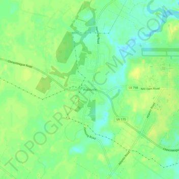
Name: Wattsville topographic map, elevation, terrain.
Location: Wattsville, Accomack County, Virginia, 23483, United States (37.91401 -75.51965 37.95401 -75.47965)
Average elevation: 36 ft
Minimum elevation: -3 ft
Maximum elevation: 62 ft
Accomack County trails, hiking, mountain biking, running and outdoor activities
Make a donation
Gear up for your next adventure:
As an Amazon Associate, this site earns from qualifying purchases at no extra cost to you.
Other topographic maps
Click on a map to view its topography, its elevation and its terrain.
Painter
United States > Virginia > Accomack County
It lies at an elevation of 36 feet.
Average elevation: 33 ft