
Make a donation
Gear up for your next adventure:
As an Amazon Associate, this site earns from qualifying purchases at no extra cost to you.
Nennig topographic map
Click on the map to display elevation.
Make a donation
Gear up for your next adventure:
As an Amazon Associate, this site earns from qualifying purchases at no extra cost to you.
Nennig
Die Gesteinsgrundlage stellt in Nennig fast überall der Hauptmuschelkalk dar. Von den Höhen des Saar-Mosel-Gaues (Saargau) fällt die Landschaft terrassenartig zur Mosel hin ab. Zahlreiche der Mosel zulaufende Tälchen bauen flache Schwemmkegel in die Moseltalniederung vor, die hier auf einer Länge von 9 km auf rund 1,8 km verbreitert ist.
Make a donation
Gear up for your next adventure:
As an Amazon Associate, this site earns from qualifying purchases at no extra cost to you.
About this map
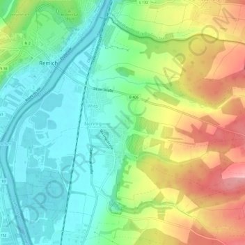
Name: Nennig topographic map, elevation, terrain.
Location: Nennig, Perl, Landkreis Merzig-Wadern, Saarland, Deutschland (49.51865 6.35760 49.55137 6.41580)
Average elevation: 623 ft
Minimum elevation: 446 ft
Maximum elevation: 919 ft
Make a donation
Gear up for your next adventure:
As an Amazon Associate, this site earns from qualifying purchases at no extra cost to you.
Other topographic maps
Click on a map to view its topography, its elevation and its terrain.
Pillinger Hof
Deutschland > Saarland > Landkreis Merzig-Wadern > Perl > Borg
Average elevation: 1,040 ft