
Kottiyam topographic map
Interactive map
Click on the map to display elevation.
About this map
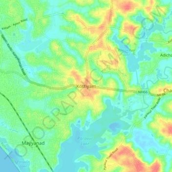
Name: Kottiyam topographic map, elevation, terrain.
Location: Kottiyam, Kollam, Kollam District, Kerala, 691571, India (8.82603 76.63095 8.90603 76.71095)
Average elevation: 56 ft
Minimum elevation: -16 ft
Maximum elevation: 171 ft
Other topographic maps
Click on a map to view its topography, its elevation and its terrain.
Chirakkara
Chirakkara, Kollam, Kollam District, Kerala, 691578, India
Average elevation: 118 ft
Ashtamudi Lake
India > Kerala > Kollam > Kottayathukadavu
Ashtamudi Lake, Kottayathukadavu, Kollam, Kerala, India
Average elevation: 20 ft
Kizhakkekallada
Kizhakkekallada, Kollam, Kerala, 691502, India
Average elevation: 33 ft
Kalluvathukkal
Kalluvathukkal, Kollam, Kerala, 691578, India
Average elevation: 131 ft
Anchalummood
Anchalummood, Kollam, Kerala, 691601, India
Average elevation: 33 ft
Nellimukku
India > Kerala > Kollam > Kollam
Nellimukku, Kaankathu, Thangasseri, Kollam, Kerala, 691001, India
Average elevation: 33 ft