Geolocate

Anchalummood topographic map

Click on the map to display elevation.

About this map

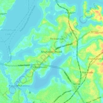
Name: Anchalummood topographic map, elevation, terrain.

Location: Anchalummood, Kollam, Kerala, 691601, India (8.89243 76.56411 8.97243 76.64411)

Average elevation: 33 ft

Minimum elevation: 3 ft

Maximum elevation: 118 ft

Other topographic maps

Click on a map to view its topography, its elevation and its terrain.

Ashtamudi Lake

India > Kerala > Kollam > Kottayathukadavu

Ashtamudi Lake (Ashtamudi Kayal), in the Kollam District of the Indian state of Kerala, is the most visited backwater and lake in the state. It possesses a unique wetland ecosystem and a large palm-shaped (also described as octopus-shaped) water body, second only in size to the Vembanad estuary ecosystem of…

Average elevation: 20 ft

Mukhathala Kulam

India > Kerala > Kollam > Thrikkovilvattom

Average elevation: 59 ft

Kollam

India > Kerala > Kollam > Eravipuram

Average elevation: 30 ft

Pozhikara Temple Pond

India > Kerala > Kollam > Paravur

Average elevation: 16 ft

Kundara

India > Kerala > Kollam > Kundara

Average elevation: 105 ft

Ithikkara

India > Kerala > Kollam > Nellettil

Average elevation: 115 ft

Gear up for your next adventure:

🕶️GPS Smartphone Mount - Secure mount for phone navigation
🧯Emergency Survival Kit - All‑in‑one survival essentials for the backcountry
🛡️Insect Repellent - Protection against bugs during outdoor activities
📚Navigation Handbooks - Master the art of reading topographic maps and using a compass
🔌USB Car Charger - Car charger for on‑the‑go power needs

As an Amazon Associate, this site earns from qualifying purchases at no extra cost to you.