
Mühlau topographic map
Interactive map
Click on the map to display elevation.
About this map
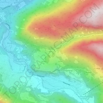
Name: Mühlau topographic map, elevation, terrain.
Location: Mühlau, Oetz, Bezirk Imst, 6433, Oostenrijk (47.19656 10.86470 47.23656 10.90470)
Average elevation: 3,612 ft
Minimum elevation: 2,264 ft
Maximum elevation: 5,974 ft
Other topographic maps
Click on a map to view its topography, its elevation and its terrain.
Klingenburg
Oostenrijk > Bezirk Imst > Oetz
Klingenburg, Oetz, Bezirk Imst, 6433, Oostenrijk
Average elevation: 3,812 ft