
Make a donation
Gear up for your next adventure:
As an Amazon Associate, this site earns from qualifying purchases at no extra cost to you.
Ridgway topographic map
Click on the map to display elevation.
Make a donation
Gear up for your next adventure:
As an Amazon Associate, this site earns from qualifying purchases at no extra cost to you.
Ridgway
Ridgway is situated in the Uncompahgre Valley at an elevation of 6,985 feet (2,129 m). The town is located on the San Juan Skyway, cradled in the heart of some of the most photographed mountains in the world. The nearby San Juan Mountain Range has 14 of Colorado's 53 peaks over 14,000 feet. Among them, 14,150 feet (4,310 m) Mt. Sneffels is most prominent from Ridgway. The eponymous Mt. Ridgway, 13,468 feet (4,105 m) in height, is also nearby, 4.5 miles (7.2 km) west of Ouray. To the east of the town also lies the smaller but equally-grand Cimarron Range, with Uncompahgre Peak at 14,309 feet (4,361 m).
Make a donation
Gear up for your next adventure:
As an Amazon Associate, this site earns from qualifying purchases at no extra cost to you.
About this map
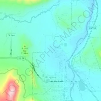
Name: Ridgway topographic map, elevation, terrain.
Location: Ridgway, Ouray County, Colorado, 81432, United States (38.14497 -107.76932 38.17818 -107.73559)
Average elevation: 7,129 ft
Minimum elevation: 6,932 ft
Maximum elevation: 8,022 ft
Ouray County trails, hiking, mountain biking, running and outdoor activities
Make a donation
Gear up for your next adventure:
As an Amazon Associate, this site earns from qualifying purchases at no extra cost to you.
Other topographic maps
Click on a map to view its topography, its elevation and its terrain.
Ouray
United States > Colorado > Ouray County
Ouray (/ˈjʊəreɪ/ YOOR-ay) is a home rule municipality that is the county seat of Ouray County, Colorado, United States. The city population was 898 as of the 2020 census. The Ouray Post Office has the ZIP Code 81427. Located at an elevation of 7,792 feet (2,375 m), Ouray's climate, natural alpine…
Average elevation: 8,914 ft
Make a donation
Gear up for your next adventure:
As an Amazon Associate, this site earns from qualifying purchases at no extra cost to you.