
Make a donation
Gear up for your next adventure:
As an Amazon Associate, this site earns from qualifying purchases at no extra cost to you.
Holguín topographic map
Click on the map to display elevation.
Make a donation
Gear up for your next adventure:
As an Amazon Associate, this site earns from qualifying purchases at no extra cost to you.
About this map
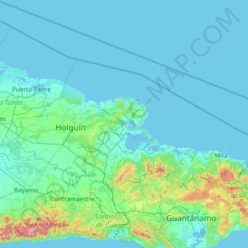
Name: Holguín topographic map, elevation, terrain.
Location: Holguín, Cuba (20.38358 -76.73163 21.44104 -74.56673)
Average elevation: 331 ft
Minimum elevation: -13 ft
Maximum elevation: 6,053 ft
Make a donation
Gear up for your next adventure:
As an Amazon Associate, this site earns from qualifying purchases at no extra cost to you.
Other topographic maps
Click on a map to view its topography, its elevation and its terrain.
Havana
Cuba > Havana > La Habana Vieja
There are low hills on which the city lies rise gently from the waters of the straits. A noteworthy elevation is the 200-foot-high (60-meter) limestone ridge that slopes up from the east and culminates in the heights of La Cabaña and El Morro, the sites of Spanish fortifications overlooking the eastern bay.…
Average elevation: 98 ft