
Make a donation
Gear up for your next adventure:
As an Amazon Associate, this site earns from qualifying purchases at no extra cost to you.
Rena topographic map
Click on the map to display elevation.
Make a donation
Gear up for your next adventure:
As an Amazon Associate, this site earns from qualifying purchases at no extra cost to you.
About this map
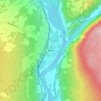
Name: Rena topographic map, elevation, terrain.
Location: Rena, Åmot, Innlandet, Norway (61.11276 11.35220 61.15276 11.39220)
Average elevation: 922 ft
Minimum elevation: 673 ft
Maximum elevation: 1,362 ft
Make a donation
Gear up for your next adventure:
As an Amazon Associate, this site earns from qualifying purchases at no extra cost to you.
Other topographic maps
Click on a map to view its topography, its elevation and its terrain.
Hamar
Hamar has a humid continental climate (Dfb) with fairly dry and cold winters, and comfortably warm summers. The Hamar II weather station, at an elevation of 141 metres (463 ft), started recording in 1968. The all-time high 33 °C (91 °F) was recorded in July 2018, which was the warmest month on record with…
Average elevation: 1,460 ft