Geolocate

Mook topographic map

Click on the map to display elevation.

About this map

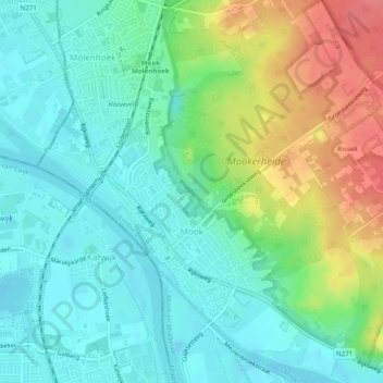
Name: Mook topographic map, elevation, terrain.

Location: Mook, Mook en Middelaar, Limburg, Netherlands (51.74065 5.87052 51.77081 5.91528)

Average elevation: 95 ft

Minimum elevation: 20 ft

Maximum elevation: 249 ft

Other topographic maps

Click on a map to view its topography, its elevation and its terrain.

Heierhoeven

Netherlands > Limburg > Venlo

Average elevation: 89 ft

Mariapeel

Netherlands > Limburg > Evertsoord

Average elevation: 105 ft

Cottessen

Netherlands > Limburg > Vijlen

Average elevation: 600 ft

Overheek

Netherlands > Limburg > Termaar

Average elevation: 387 ft

Maastricht

Netherlands > Limburg > Maastricht

Average elevation: 331 ft

Horick

Netherlands > Limburg > Ospel > Horick

Average elevation: 105 ft

Schimmert

Netherlands > Limburg > Schimmert > Schimmert

Average elevation: 410 ft

Hout-Blerick

Netherlands > Limburg > Venlo

Average elevation: 72 ft

Gear up for your next adventure:

🥇GPS Hiking Watch - Multi‑sport GPS watch with navigation and trail tracking
🎒Waterproof Dry Bags - Keep your electronics and maps dry inside your pack
📚Navigation Handbooks - Master the art of reading topographic maps and using a compass
⛑️Personal Locator Beacon - Safety beacon for emergencies
🌐World Map Poster - Decorative world maps with topographic info

As an Amazon Associate, this site earns from qualifying purchases at no extra cost to you.