Geolocate

Jerash topographic map

Click on the map to display elevation.

About this map

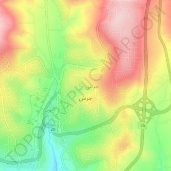
Name: Jerash topographic map, elevation, terrain.

Location: Jerash, Jerash Sub-District, Qasabah Jerash, Jarash, Jordan (32.26831 35.87688 32.29818 35.91256)

Average elevation: 2,077 ft

Minimum elevation: 1,647 ft

Maximum elevation: 2,467 ft

Other topographic maps

Click on a map to view its topography, its elevation and its terrain.

Sakib

Jordan > Jarash > Jerash Sub-District

Average elevation: 2,096 ft

Nebi Hud

Jordan > Jarash > Jerash Sub-District

Average elevation: 1,854 ft

Kafr Khal

Jordan > Jarash > Jerash Sub-District

Average elevation: 3,179 ft

Gear up for your next adventure:

🧷Carabiner Set - Durable clips for gear attachment
🌎3D Topographic Globes - Raised relief globes for a tactile understanding of geography
❄️Traction Cleats - Prevent slips on icy trails during winter hikes
🥾Women's Hiking Boots - Top-rated trail boots with ankle support and superior grip
🦟Ultrasonic Repellers - Create a bug-free zone at your camp or rest stop

As an Amazon Associate, this site earns from qualifying purchases at no extra cost to you.