
Make a donation
Gear up for your next adventure:
As an Amazon Associate, this site earns from qualifying purchases at no extra cost to you.
Beauvoorde topographic map
Click on the map to display elevation.
Make a donation
Gear up for your next adventure:
As an Amazon Associate, this site earns from qualifying purchases at no extra cost to you.
About this map
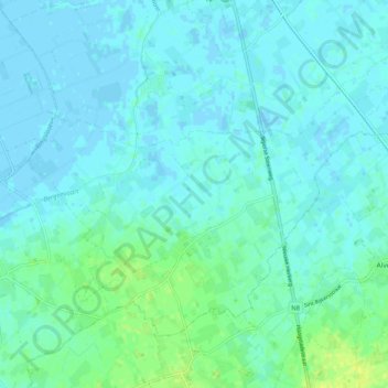
Name: Beauvoorde topographic map, elevation, terrain.
Location: Beauvoorde, Veurne, West-Vlaanderen, Vlaanderen, België (51.00035 2.61506 51.04665 2.71592)
Average elevation: 13 ft
Minimum elevation: -13 ft
Maximum elevation: 46 ft
Make a donation
Gear up for your next adventure:
As an Amazon Associate, this site earns from qualifying purchases at no extra cost to you.
Other topographic maps
Click on a map to view its topography, its elevation and its terrain.
Westhoekduinen, duinen van Cabour, De Moeren en plateau van Izenberge
België > West-Vlaanderen > Veurne > Veurne
Average elevation: 3 ft
Make a donation
Gear up for your next adventure:
As an Amazon Associate, this site earns from qualifying purchases at no extra cost to you.