
Thank you for supporting this site ❤️
Make a donation
Make a donation
Gear up for your next adventure:
As an Amazon Associate, this site earns from qualifying purchases at no extra cost to you.
Jayarane topographic map
Click on the map to display elevation.
Thank you for supporting this site ❤️
Make a donation
Make a donation
Gear up for your next adventure:
As an Amazon Associate, this site earns from qualifying purchases at no extra cost to you.
About this map
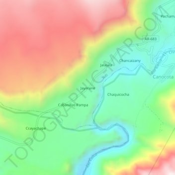
Name: Jayarane topographic map, elevation, terrain.
Location: Jayarane, Tuti, Caylloma, Arequipa, Perú (-15.58324 -71.60085 -15.54324 -71.56085)
Average elevation: 13,110 ft
Minimum elevation: 11,932 ft
Maximum elevation: 14,672 ft
Thank you for supporting this site ❤️
Make a donation
Make a donation
Gear up for your next adventure:
As an Amazon Associate, this site earns from qualifying purchases at no extra cost to you.