Geolocate

Vulcano topographic map

Click on the map to display elevation.

About this map

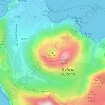
Name: Vulcano topographic map, elevation, terrain.

Location: Vulcano, Lipari, Messina, Sicily, Italy (38.40437 14.96175 38.40447 14.96185)

Average elevation: 407 ft

Minimum elevation: 0 ft

Maximum elevation: 1,352 ft

Other topographic maps

Click on a map to view its topography, its elevation and its terrain.

Isola di Vulcano

Italy > Sicily > Messina > Lipari

Average elevation: 249 ft

Isola di Stromboli

Italy > Sicily > Messina > Lipari

Average elevation: 525 ft

Alicudi

Italy > Sicily > Messina > Lipari

Average elevation: 505 ft

Alicudi

Italy > Sicily > Messina > Lipari

Average elevation: 505 ft

Gear up for your next adventure:

🧭Compass with Lanyard - Easy‑carry compass for navigation
🎁Geography Themed Gifts - Unique gift ideas for map lovers and geography enthusiasts
🔦Powerful Headlamps - Ultra-bright hands-free lighting for night navigation
🔥Camping Stove - Portable stove for camping and backcountry cooking
🧭Hiking Compass - Precision compass for reliable navigation in the wilderness

As an Amazon Associate, this site earns from qualifying purchases at no extra cost to you.