Geolocate

Hopla topographic map

Click on the map to display elevation.

About this map

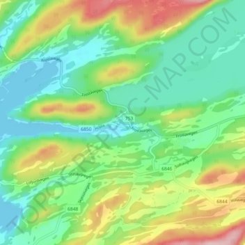
Name: Hopla topographic map, elevation, terrain.

Location: Hopla, Levanger, Trøndelag, 7632, Norway (63.58304 10.93890 63.62304 10.97890)

Average elevation: 210 ft

Minimum elevation: 0 ft

Maximum elevation: 623 ft

Other topographic maps

Click on a map to view its topography, its elevation and its terrain.

Heim

Norway > Trøndelag

Average elevation: 945 ft

Holtålen

Norway > Trøndelag

Average elevation: 2,569 ft

Frøya

Norway > Trøndelag

Average elevation: 13 ft

Kya

Norway > Trøndelag

Average elevation: 0 ft

Stjørdal

Norway > Trøndelag

Average elevation: 1,030 ft

Gear up for your next adventure:

📻Weather Alert Radios - Stay informed of storm risks while off-the-grid
🔥Fast-Boil Camping Stoves - Efficient cooking systems for quick trail meals
🧣Hiking Neck Gaiter - Multi‑use neck protection for outdoor weather
📡Handheld GPS Device - Reliable handheld GPS for outdoor navigation
🦶Carbon Trekking Poles - Reduce knee impact on steep descents with ultra-light poles

As an Amazon Associate, this site earns from qualifying purchases at no extra cost to you.