Geolocate

Topsail Beach topographic map

Click on the map to display elevation.

About this map

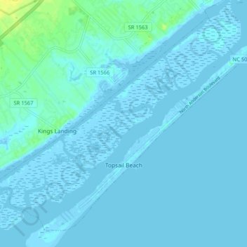
Name: Topsail Beach topographic map, elevation, terrain.

Location: Topsail Beach, Pender County, North Carolina, United States (34.34759 -77.67322 34.40488 -77.59302)

Average elevation: 7 ft

Minimum elevation: -13 ft

Maximum elevation: 56 ft

Pender County trails, hiking, mountain biking, running and outdoor activities

Other topographic maps

Click on a map to view its topography, its elevation and its terrain.

Willard

United States > North Carolina > Pender County

Average elevation: 52 ft

Currie

United States > North Carolina > Pender County

Average elevation: 30 ft

Surf City

United States > North Carolina > Pender County

Average elevation: 33 ft

Sunnyside

United States > North Carolina > Pender County

Average elevation: 56 ft

Shaken

United States > North Carolina > Pender County

Average elevation: 20 ft

Gear up for your next adventure:

🧤Tactile Hiking Gloves - Keep hands warm while operating GPS and smartphone screens
🏫Relief Map Kits - Hands-on tools for teaching landforms and elevation
🚪Portable Camp Chair - Foldable chair for comfort at camp
🏔️Mountain Trail Maps - High‑detail maps for popular peaks
📡GPS Antenna Upgrade - Enhance GPS reception in remote terrain

As an Amazon Associate, this site earns from qualifying purchases at no extra cost to you.