
Make a donation
Gear up for your next adventure:
As an Amazon Associate, this site earns from qualifying purchases at no extra cost to you.
Brünen topographic map
Click on the map to display elevation.
Make a donation
Gear up for your next adventure:
As an Amazon Associate, this site earns from qualifying purchases at no extra cost to you.
Brünen
Brünen liegt südöstlich von Hamminkeln auf einer Höhe zwischen 35 und 50 m ü. NHN, was in der Region Niederrhein bereits als höhere Lage bezeichnet werden kann. In Ortsnähe treffen sich die Bundesstraße 70, die Landesstraßen 1 und 480 sowie die Kreisstraße 26.
Make a donation
Gear up for your next adventure:
As an Amazon Associate, this site earns from qualifying purchases at no extra cost to you.
About this map
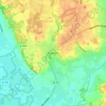
Name: Brünen topographic map, elevation, terrain.
Average elevation: 125 ft
Minimum elevation: 72 ft
Maximum elevation: 187 ft
Make a donation
Gear up for your next adventure:
As an Amazon Associate, this site earns from qualifying purchases at no extra cost to you.
Other topographic maps
Click on a map to view its topography, its elevation and its terrain.
Dingdener Heide
Deutschland > Nordrhein-Westfalen > Kreis Wesel > Hamminkeln
Average elevation: 161 ft