Geolocate

The Narth topographic map

Click on the map to display elevation.

About this map

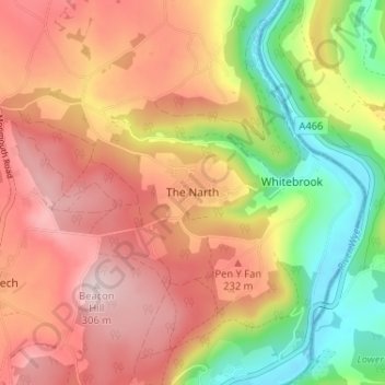
Name: The Narth topographic map, elevation, terrain.

Location: The Narth, Monmouthshire, Wales, NP25 4QW, United Kingdom (51.73452 -2.71173 51.77452 -2.67173)

Average elevation: 558 ft

Minimum elevation: 16 ft

Maximum elevation: 994 ft

Other topographic maps

Click on a map to view its topography, its elevation and its terrain.

Wye Valley

United Kingdom > Wales > Monmouthshire

Average elevation: 548 ft

Chepstow Castle

United Kingdom > Wales > Monmouthshire > Chepstow

Average elevation: 174 ft

Penallt

United Kingdom > Wales > Monmouthshire

Average elevation: 571 ft

Crucorney

United Kingdom > Wales > Monmouthshire

Average elevation: 974 ft

Blorenge

United Kingdom > Wales > Monmouthshire > Govilon

Average elevation: 1,293 ft

River Monnow

United Kingdom > Wales > Monmouthshire

Average elevation: 564 ft

Llanbadoc

United Kingdom > Wales > Monmouthshire

Average elevation: 256 ft

Raglan Castle

United Kingdom > Wales > Monmouthshire > Raglan

Average elevation: 194 ft

River Monnow

United Kingdom > Wales > Monmouthshire

Average elevation: 564 ft

Gear up for your next adventure:

🔭Compact Binoculars - HD vision for scouting terrain and identifying distant landmarks
🧤Tactile Hiking Gloves - Keep hands warm while operating GPS and smartphone screens
📱Solar Portable Charger - Solar power bank for charging devices off‑grid
🎒Trail Energy Bars - High‑calorie bars for hiking energy
🪑Ultralight Camp Chairs - Portable seating for resting after a long day of mapping

As an Amazon Associate, this site earns from qualifying purchases at no extra cost to you.