Geolocate

Loja topographic map

Click on the map to display elevation.

About this map

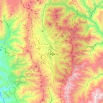
Name: Loja topographic map, elevation, terrain.

Location: Loja, Ecuador (-4.13286 -79.26995 -3.85011 -79.13738)

Average elevation: 7,575 ft

Minimum elevation: 4,026 ft

Maximum elevation: 11,650 ft

Other topographic maps

Click on a map to view its topography, its elevation and its terrain.

Mollepamba

Ecuador > Loja > Loja > Vilcabamba

Average elevation: 6,024 ft

Santorum

Ecuador > Loja > Loja > Vilcabamba

Average elevation: 5,269 ft

Taxiche

Ecuador > Loja > Loja > Malacatos

Average elevation: 5,285 ft

Santiago

Ecuador > Loja > Loja > Santiago

Average elevation: 7,887 ft

Numba

Ecuador > Loja > Loja > San Pedro de Vilcabamba

Average elevation: 7,470 ft

Cresta de Gallo

Ecuador > Loja > Loja > Vilcabamba

Average elevation: 11,020 ft

Gear up for your next adventure:

🧤Tactile Hiking Gloves - Keep hands warm while operating GPS and smartphone screens
💧Water Filtration Bottles - Safely drink from streams and lakes while exploring
📡Handheld GPS Device - Reliable handheld GPS for outdoor navigation
🔦Compact Flashlight - Reliable flashlight for emergencies
🧴Hand Sanitizer - Keep hands clean while hiking

As an Amazon Associate, this site earns from qualifying purchases at no extra cost to you.