
Thank you for supporting this site ❤️
Make a donation
Make a donation
Gear up for your next adventure:
As an Amazon Associate, this site earns from qualifying purchases at no extra cost to you.
Unha topographic map
Click on the map to display elevation.
Thank you for supporting this site ❤️
Make a donation
Make a donation
Gear up for your next adventure:
As an Amazon Associate, this site earns from qualifying purchases at no extra cost to you.
Unha
Uña se encuentra a poca distancia de Salardú, enclavado en el Norte, a unos 1280 metros de altitud sobre el nivel del mar, a los pies del Poi d'Unha, próxima en el SE al río Unhóla, antes de confluir con el Garona.
Thank you for supporting this site ❤️
Make a donation
Make a donation
Gear up for your next adventure:
As an Amazon Associate, this site earns from qualifying purchases at no extra cost to you.
About this map
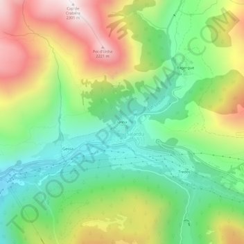
Name: Unha topographic map, elevation, terrain.
Average elevation: 5,236 ft
Minimum elevation: 3,770 ft
Maximum elevation: 7,484 ft
Thank you for supporting this site ❤️
Make a donation
Make a donation
Gear up for your next adventure:
As an Amazon Associate, this site earns from qualifying purchases at no extra cost to you.