
Make a donation
Gear up for your next adventure:
As an Amazon Associate, this site earns from qualifying purchases at no extra cost to you.
Espargos topographic map
Click on the map to display elevation.
Make a donation
Gear up for your next adventure:
As an Amazon Associate, this site earns from qualifying purchases at no extra cost to you.
Espargos
The highest point of Espargos is Monte Curral, elevation 109 meters, where the radar station and the control tower for the airport are located. The Amílcar Cabral International Airport is situated directly southwest of the city centre. The head offices of Cabo Verde Express are located at the airport. The national road EN1-SL01, a dual carriageway, connects Espargos with Santa Maria in the south of the island. Other national roads connect it with Pedra de Lume and Palmeira.
Make a donation
Gear up for your next adventure:
As an Amazon Associate, this site earns from qualifying purchases at no extra cost to you.
About this map
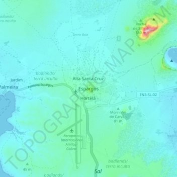
Name: Espargos topographic map, elevation, terrain.
Location: Espargos, Sal, 4110, Cape Verde (16.71780 -22.98315 16.79780 -22.90315)
Average elevation: 112 ft
Minimum elevation: -7 ft
Maximum elevation: 948 ft
Make a donation
Gear up for your next adventure:
As an Amazon Associate, this site earns from qualifying purchases at no extra cost to you.