
Make a donation
Gear up for your next adventure:
As an Amazon Associate, this site earns from qualifying purchases at no extra cost to you.
Hochfirst topographic map
Click on the map to display elevation.
Make a donation
Gear up for your next adventure:
As an Amazon Associate, this site earns from qualifying purchases at no extra cost to you.
Hochfirst
Der Hochfirst ist ein bewaldeter Berg zwischen Saig und Titisee-Neustadt im Südschwarzwald mit einer Höhe von 1196,9 m ü. NHN.
Make a donation
Gear up for your next adventure:
As an Amazon Associate, this site earns from qualifying purchases at no extra cost to you.
About this map
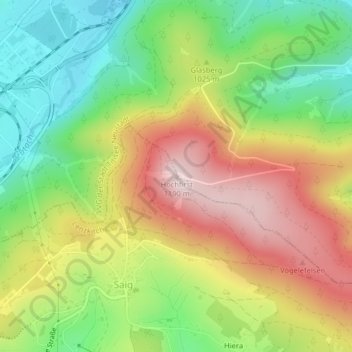
Name: Hochfirst topographic map, elevation, terrain.
Average elevation: 3,261 ft
Minimum elevation: 2,710 ft
Maximum elevation: 3,911 ft
Make a donation
Gear up for your next adventure:
As an Amazon Associate, this site earns from qualifying purchases at no extra cost to you.
Other topographic maps
Click on a map to view its topography, its elevation and its terrain.
Raitenbuch
Deutschland > Baden-Württemberg > Landkreis Breisgau-Hochschwarzwald > Lenzkirch
Average elevation: 3,268 ft