Corpus Christi topographic map
Click on the map to display elevation.
Corpus Christi
Corpus Christi features a diverse coastal topography characterized by its proximity to the Gulf of Mexico. The landscape includes sandy beaches, barrier islands, and extensive estuarine systems such as the Nueces Estuary and Corpus Christi Bay, which are crucial habitats for wildlife. The region is predominantly flat with elevations generally ranging from sea level to approximately 30 feet (9 meters) above sea level, making it prone to coastal influences and susceptible to flooding during storms. Additionally, the area is dotted with salt marshes and wetlands, contributing to its ecological richness while supporting a variety of marine and terrestrial species.
About this map
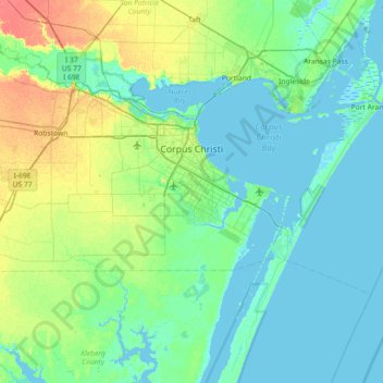
Name: Corpus Christi topographic map, elevation, terrain.
Location: Corpus Christi, Nueces County, Texas, United States (27.48357 -97.68274 27.89964 -96.96111)
Average elevation: 26 ft
Minimum elevation: -10 ft
Maximum elevation: 125 ft
Nueces County trails, hiking, mountain biking, running and outdoor activities
Other topographic maps
Click on a map to view its topography, its elevation and its terrain.