
Make a donation
Gear up for your next adventure:
As an Amazon Associate, this site earns from qualifying purchases at no extra cost to you.
Horseshoe Bend topographic map
Click on the map to display elevation.
Make a donation
Gear up for your next adventure:
As an Amazon Associate, this site earns from qualifying purchases at no extra cost to you.
Horseshoe Bend
The area was originally settled as a gold miners' staging area, as prospectors waited along the river for snows to thaw at the higher elevations. Gold had been discovered in 1862 in the Boise Basin mountains to the east, near Idaho City.
Make a donation
Gear up for your next adventure:
As an Amazon Associate, this site earns from qualifying purchases at no extra cost to you.
About this map
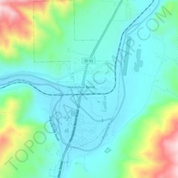
Name: Horseshoe Bend topographic map, elevation, terrain.
Location: Horseshoe Bend, Boise County, Idaho, United States (43.89845 -116.21011 43.92994 -116.18873)
Average elevation: 2,844 ft
Minimum elevation: 2,572 ft
Maximum elevation: 3,691 ft
Boise County trails, hiking, mountain biking, running and outdoor activities
Make a donation
Gear up for your next adventure:
As an Amazon Associate, this site earns from qualifying purchases at no extra cost to you.
Other topographic maps
Click on a map to view its topography, its elevation and its terrain.
Make a donation
Gear up for your next adventure:
As an Amazon Associate, this site earns from qualifying purchases at no extra cost to you.
Make a donation
Gear up for your next adventure:
As an Amazon Associate, this site earns from qualifying purchases at no extra cost to you.