
Make a donation
Gear up for your next adventure:
As an Amazon Associate, this site earns from qualifying purchases at no extra cost to you.
L'Essert topographic map
Click on the map to display elevation.
Make a donation
Gear up for your next adventure:
As an Amazon Associate, this site earns from qualifying purchases at no extra cost to you.
About this map
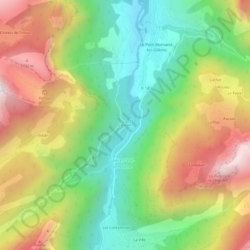
Name: L'Essert topographic map, elevation, terrain.
Average elevation: 3,898 ft
Minimum elevation: 2,139 ft
Maximum elevation: 6,175 ft
Make a donation
Gear up for your next adventure:
As an Amazon Associate, this site earns from qualifying purchases at no extra cost to you.
Other topographic maps
Click on a map to view its topography, its elevation and its terrain.
Le Petit-Bornand-les-Glières
France > Auvergne-Rhône-Alpes > Haute-Savoie > Glières-Val-de-Borne
Les réserves d'eau situées en altitude sourdent souvent et font pleurer la falaise de Leschaux.
Average elevation: 4,482 ft
Plan du Loup
France > Auvergne-Rhône-Alpes > Haute-Savoie > Glières-Val-de-Borne
Average elevation: 5,003 ft