
Thank you for supporting this site ❤️
Make a donation
Make a donation
Gear up for your next adventure:
As an Amazon Associate, this site earns from qualifying purchases at no extra cost to you.
Zinalrothorn topographic map
Click on the map to display elevation.
Thank you for supporting this site ❤️
Make a donation
Make a donation
Gear up for your next adventure:
As an Amazon Associate, this site earns from qualifying purchases at no extra cost to you.
About this map
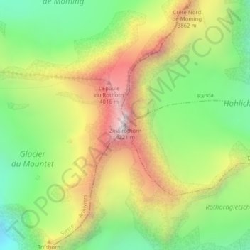
Name: Zinalrothorn topographic map, elevation, terrain.
Location: Zinalrothorn, Anniviers, Sierre, Valais, 3961, Suisse (46.06478 7.69007 46.06488 7.69017)
Average elevation: 11,529 ft
Minimum elevation: 9,810 ft
Maximum elevation: 13,720 ft
Thank you for supporting this site ❤️
Make a donation
Make a donation
Gear up for your next adventure:
As an Amazon Associate, this site earns from qualifying purchases at no extra cost to you.
Other topographic maps
Click on a map to view its topography, its elevation and its terrain.