Geolocate

Gilman topographic map

Click on the map to display elevation.

About this map

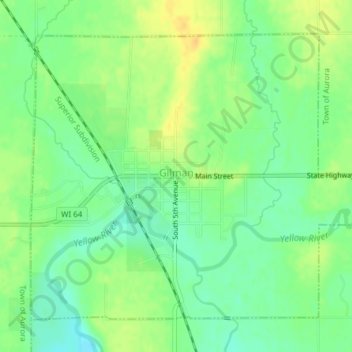
Name: Gilman topographic map, elevation, terrain.

Location: Gilman, Taylor County, Wisconsin, United States (45.15534 -90.82350 45.17729 -90.78701)

Average elevation: 1,230 ft

Minimum elevation: 1,184 ft

Maximum elevation: 1,276 ft

Taylor County trails, hiking, mountain biking, running and outdoor activities

Other topographic maps

Click on a map to view its topography, its elevation and its terrain.

Maplehurst

United States > Wisconsin > Taylor County > Maplehurst

Average elevation: 1,276 ft

Westboro

United States > Wisconsin > Taylor County

Average elevation: 1,532 ft

Spirit Lake

United States > Wisconsin > Taylor County

Average elevation: 1,647 ft

Murat

United States > Wisconsin > Taylor County

Average elevation: 1,424 ft

Gear up for your next adventure:

🕶️GPS Smartphone Mount - Secure mount for phone navigation
📻Weather Alert Radios - Stay informed of storm risks while off-the-grid
🛰️Handheld GPS Units - Professional satellite navigators for precise backcountry mapping
🧭Outdoor Navigation Book - Learn advanced navigation skills
🛶Inflatable Kayak - Portable kayak for rivers, lakes, and expeditions

As an Amazon Associate, this site earns from qualifying purchases at no extra cost to you.