Geolocate

Tudela topographic map

Click on the map to display elevation.

About this map

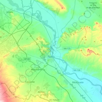
Name: Tudela topographic map, elevation, terrain.

Location: Tudela, Ribera / Erribera, Navarre, 31500, Spain (41.99260 -1.83806 42.16396 -1.48451)

Average elevation: 1,083 ft

Minimum elevation: 771 ft

Maximum elevation: 2,195 ft

Gear up for your next adventure:

🪶Paracord Bracelet - Survival bracelet with built‑in tools
🥩Freeze-Dried Meals - Nutritious and lightweight food for remote expeditions
🪄Magnetic Compass - Accurate compass for navigation
🔦LED Headlamp - Bright and durable LED headlamp for night navigation
🧺Microfiber Travel Towels - Compact and fast-drying towels for trail use

As an Amazon Associate, this site earns from qualifying purchases at no extra cost to you.