Geolocate

Linslade topographic map

Click on the map to display elevation.

About this map

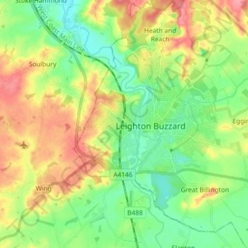
Name: Linslade topographic map, elevation, terrain.

Location: Linslade, Central Bedfordshire, England, LU7 2RG, United Kingdom (51.87706 -0.71601 51.95706 -0.63601)

Average elevation: 341 ft

Minimum elevation: 236 ft

Maximum elevation: 495 ft

Other topographic maps

Click on a map to view its topography, its elevation and its terrain.

Ampthill

United Kingdom > England > Central Bedfordshire

Average elevation: 279 ft

Tempsford

United Kingdom > England > Central Bedfordshire

Elevation

Average elevation: 72 ft

Dunstable

United Kingdom > England > Central Bedfordshire

Average elevation: 518 ft

Clifton

United Kingdom > England > Central Bedfordshire

Average elevation: 148 ft

Gear up for your next adventure:

🔭Stargazing Telescopes - Perfect for camping in low-light pollution areas shown on maps
👓Polarized Sunglasses - Outdoor sunglasses for glare reduction
🎒Waterproof Dry Bags - Keep your electronics and maps dry inside your pack
📡Handheld GPS Device - Reliable handheld GPS for outdoor navigation
🗺️Topographic Maps - Detailed topo maps for hiking, exploring and outdoor navigation

As an Amazon Associate, this site earns from qualifying purchases at no extra cost to you.