
Make a donation
Gear up for your next adventure:
As an Amazon Associate, this site earns from qualifying purchases at no extra cost to you.
Harris Mountains topographic map
Click on the map to display elevation.
Make a donation
Gear up for your next adventure:
As an Amazon Associate, this site earns from qualifying purchases at no extra cost to you.
About this map
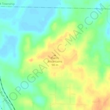
Name: Harris Mountains topographic map, elevation, terrain.
Average elevation: 269 ft
Minimum elevation: 220 ft
Maximum elevation: 328 ft
Make a donation
Gear up for your next adventure:
As an Amazon Associate, this site earns from qualifying purchases at no extra cost to you.
Other topographic maps
Click on a map to view its topography, its elevation and its terrain.
Pine Bluff
United States > Arkansas > Jefferson County
The city is situated in the Southeast section of the Arkansas Delta and straddles the Arkansas Timberlands region to its west. Its topography is flat with wide expanses of farmland, similar to other places in the Delta Lowlands. Pine Bluff has numerous creeks, streams, and bayous, including Bayou Bartholomew,…
Average elevation: 226 ft
Make a donation
Gear up for your next adventure:
As an Amazon Associate, this site earns from qualifying purchases at no extra cost to you.