Geolocate

Barreo topographic map

Click on the map to display elevation.

About this map

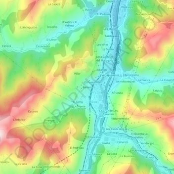
Name: Barreo topographic map, elevation, terrain.

Location: Barreo, Uxo, Mieres, Asturias, 33640, Spain (43.18826 -5.81340 43.22826 -5.77340)

Average elevation: 1,273 ft

Minimum elevation: 709 ft

Maximum elevation: 2,146 ft

Gear up for your next adventure:

🧣Hiking Neck Gaiter - Multi‑use neck protection for outdoor weather
📶Vehicle Signal Boosters - Improve reception in rural areas while driving to trailheads
🗺️Topographic Maps - Detailed topo maps for hiking, exploring and outdoor navigation
🔭Telescopic Hiking Pole - Adjustable pole for hiking stability
🪶Camp Gear Gift Set - Perfect gift bundle for outdoor fans

As an Amazon Associate, this site earns from qualifying purchases at no extra cost to you.