
Make a donation
Gear up for your next adventure:
As an Amazon Associate, this site earns from qualifying purchases at no extra cost to you.
Katueté topographic map
Click on the map to display elevation.
Make a donation
Gear up for your next adventure:
As an Amazon Associate, this site earns from qualifying purchases at no extra cost to you.
About this map
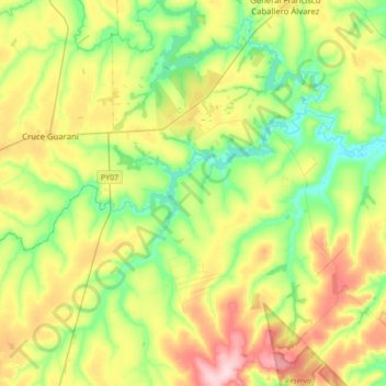
Name: Katueté topographic map, elevation, terrain.
Location: Katueté, Canindeyú, Región Oriental, Paraguay (-24.46636 -54.96200 -24.15137 -54.66272)
Average elevation: 1,115 ft
Minimum elevation: 846 ft
Maximum elevation: 1,568 ft
Make a donation
Gear up for your next adventure:
As an Amazon Associate, this site earns from qualifying purchases at no extra cost to you.
Other topographic maps
Click on a map to view its topography, its elevation and its terrain.
Salto del Guaira
La topografía accidentada, con amplios valles y terrenos planos y ondulados, favorecen la actividad agropecuaria del departamento, que lo ubica en tercer lugar en cuanto a la producción de ganado bovino, a nivel nacional. También cuenta con un importante inventario de ganado porcino y, en menor escala,…
Average elevation: 843 ft
Make a donation
Gear up for your next adventure:
As an Amazon Associate, this site earns from qualifying purchases at no extra cost to you.