
Make a donation
Gear up for your next adventure:
As an Amazon Associate, this site earns from qualifying purchases at no extra cost to you.
Mahlenzien topographic map
Click on the map to display elevation.
Make a donation
Gear up for your next adventure:
As an Amazon Associate, this site earns from qualifying purchases at no extra cost to you.
About this map
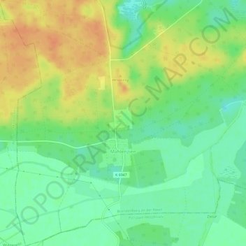
Name: Mahlenzien topographic map, elevation, terrain.
Location: Mahlenzien, Brandenburg an der Havel, Brandenburg, Deutschland (52.31155 12.41274 52.34701 12.47071)
Average elevation: 141 ft
Minimum elevation: 82 ft
Maximum elevation: 207 ft
Make a donation
Gear up for your next adventure:
As an Amazon Associate, this site earns from qualifying purchases at no extra cost to you.
Other topographic maps
Click on a map to view its topography, its elevation and its terrain.
Große Freiheit bei Plaue
Deutschland > Brandenburg > Brandenburg an der Havel > Plaue > Charlottenhof
Average elevation: 105 ft
Make a donation
Gear up for your next adventure:
As an Amazon Associate, this site earns from qualifying purchases at no extra cost to you.